Saturday, August 3, 2013
Saturday, July 27, 2013
Earth looks from SPACE
Stunning views of the world from SPACE
Photo by NASA
Wondering how earth looks from space?

Here's a collection of some photographs released by the National Aeronautics and
Space Agency of cities and continents taken from the International Space
Station in recent times
This Photo: One of the Expedition 36 crew members aboard the International Space Station, flying at altitude of approximately 257 miles above the Indian Ocean, recorded this image of the sun about to go down
This Photo: One of the Expedition 36 crew members aboard the International Space Station, flying at altitude of approximately 257 miles above the Indian Ocean, recorded this image of the sun about to go down

Moscow, Russia appears at the center of this nighttime
image photographed by one of the Expedition 30 crew members aboard the
International Space Station, flying at an altitude of approximately 240 miles.
A solar array panel for the space station is on the left side of the frame. The view is to the north-northwest from a nadir of approximately 49.4 degrees north latitude and 42.1 degrees east longitude, about 100 miles west-northwest of Volgograd.
On the horizon in the background can be seen a small sample of Aurora Borealis, airglow and daybreak.

The sun is about to set in this scene showing parts of
southwestern Australia, which was photographed by one of the Expedition 35 crew
members aboard the International Space Station on April 1, 2013

One of the crew members aboard the
International Space Station photographed this night image of the bright city of
Paris, France on April 7, 2013.

One of the Expedition 35 crew members
aboard the Earth-orbiting International Space Station exposed this 400
millimeter night image of the greater New York City metropolitan area on March
23.

This nocturnal photo of London, England was downlinked
by the Expedition 34 crew from the International Space Station, flying approximately
240 miles above Earth, on February 2, 2013. Expedition 34 Flight Engineer Chris
Hadfield, astronaut with the Canadian Space Agency, added this footnote to his
downlink: "London, on the Thames, from the city to the encircling
motorway. Heathrow very visible on the (west)."

A nighttime view of the Reno, Nevada metropolitan area
is featured in this image photographed by an Expedition 34 crew member on the
International Space Station. Known as “the biggest little city in the world”,
the city of Reno is located in Truckee Meadows along the eastern foothills of
the Sierra Nevada near the California border.
It forms part of the Reno-Sparks metropolitan area --
the largest such area in northern Nevada, and the second largest in the state
after Las Vegas.
Lake Tahoe, a major destination for skiing and other outdoor recreational activities, is located less than 50 kilometers to the southwest of the Reno-Sparks metro area. The relatively isolated nature of the metropolitan area within the surrounding terrain is highlighted in this nighttime image.
Lake Tahoe, a major destination for skiing and other outdoor recreational activities, is located less than 50 kilometers to the southwest of the Reno-Sparks metro area. The relatively isolated nature of the metropolitan area within the surrounding terrain is highlighted in this nighttime image.

This nighttime photograph, taken by one of the
Expedition 33 crew members aboard the International Space Station, features
city lights of Tokyo, on the north west side of Tokyo Bay.
North is toward the lower right-hand corner of the image. Nadir point of the location on Earth was 33.9 degrees north latitude and 139.5 degrees east longitude.
North is toward the lower right-hand corner of the image. Nadir point of the location on Earth was 33.9 degrees north latitude and 139.5 degrees east longitude.

This oblique photo of Ethiopia and part of the Red Sea
was photographed by one of the Expedition 33 crew members aboard the
International Space Station.
The name of the funnel-shaped area is the Afar Depression or Afar Triangle. The green body of water is Lake Tana, connected to the Blue Nile.
The name of the funnel-shaped area is the Afar Depression or Afar Triangle. The green body of water is Lake Tana, connected to the Blue Nile.

This oblique, night time panorama of much of Europe
was photographed by one of the Expedition 32 crew members aboard the
International Space Station flying approximately 240 miles above the
Mediterranean Sea.
The country of Italy is visible running diagonally southward from the horizon across the center of the frame, with the night lights of Rome and Naples being visible on the coast near the center. Sardinia and Corsica are just above left center of the photo, and Sicily is at lower left. The Adriatic Sea is on the other side of Italy, and beyond it to the east and north can be seen parts of several other European nations.
The country of Italy is visible running diagonally southward from the horizon across the center of the frame, with the night lights of Rome and Naples being visible on the coast near the center. Sardinia and Corsica are just above left center of the photo, and Sicily is at lower left. The Adriatic Sea is on the other side of Italy, and beyond it to the east and north can be seen parts of several other European nations.

Much of the Middle East is seen in this night time
image photographed by one of the Expedition 31 crew members aboard the
International Space Station as it flew some 240 miles above the Mediterranean
Sea.
The Nile River Delta is easily recognizable in center frame, and city lights make it easy to see both Cairo and Alexandria, Egypt near the Delta. Two Russian spacecraft -- a Soyuz (left) and a Progress -- appear in the frame while they are docked to the station.
The Nile River Delta is easily recognizable in center frame, and city lights make it easy to see both Cairo and Alexandria, Egypt near the Delta. Two Russian spacecraft -- a Soyuz (left) and a Progress -- appear in the frame while they are docked to the station.

City lights of Dubai, United Arab Emirates are
featured in this image.
The City of Dubai -- the largest metropolitan area within the emirate of Dubai -- is a favorite subject of astronaut photography largely due to the unique island developments situated directly offshore in the Persian Gulf. These artificial archipelagos have been built such that their full design is only visible from the vantage point of an airplane -- or an orbiting spacecraft such as the International Space Station. The city presents an eye-catching appearance at night that vividly displays the urban development pattern.
In this detailed nighttime image -- taken with a long focal length lens and digital camera optimized for fast response and high light sensitivity -- several interesting patterns can be observed. The highways and major streets are sharply defined by yellow-orange lighting, while the commercial and residential areas are resolved into a speckle pattern of individual white, blue, and yellow-orange lights. Several large and brilliantly lit areas are large hotel and mall complexes, including the Burj Khalifa Tower; at 828 meters (2,717 feet) height it is the world's tallest building.
The brilliant lighting of the city contrasts sharply with both the dark Persian Gulf to the northwest, and largely undeveloped and unlit areas to the southeast. Likewise, the clusters of lighting in the Palm Jumeira complex at bottom right correspond to the relatively small part of the archipelago that has been developed. Isolated areas of blurred city lights are due to patchy clouds.

One
of the crew members aboard the International Space Station took this nighttime
photograph of much of the eastern (Atlantic) coast of the United States. Large
metropolitan areas and other easily recognizable sites from the
Virginia/Maryland/Washington, D.C. area spanning almost to Rhode Island are
visible in the scene.
Boston is just out of frame at right. Long Island and the Greater Metropolitan area of New York City are visible in the lower right quadrant. Large cities in Pennsylvania (Philadelphia and Pittsburgh) are near center. Parts of two Russian vehicles parked at the orbital outpost are seen in left foreground.
Boston is just out of frame at right. Long Island and the Greater Metropolitan area of New York City are visible in the lower right quadrant. Large cities in Pennsylvania (Philadelphia and Pittsburgh) are near center. Parts of two Russian vehicles parked at the orbital outpost are seen in left foreground.

The city lights of Madrid (just right of center) stand
out in this photograph from the International Space Station.
The view shows almost the entire Iberian Peninsula (both Spain and Portugal) with the Strait of Gibraltar and Morocco appearing at lower left. What is thought to be a blur of the moon appears in upper left corner. The faint gold or brownish line of airglow--caused by ultraviolet radiation exciting the gas molecules in the upper atmosphere--parallels the horizon or Earth limb.
The view shows almost the entire Iberian Peninsula (both Spain and Portugal) with the Strait of Gibraltar and Morocco appearing at lower left. What is thought to be a blur of the moon appears in upper left corner. The faint gold or brownish line of airglow--caused by ultraviolet radiation exciting the gas molecules in the upper atmosphere--parallels the horizon or Earth limb.
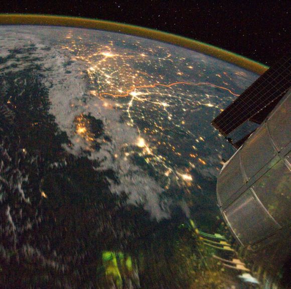
A night time view of India-Pakistan borderlands is featured
in this image photographed by a crew member on the International Space Station.
Clusters of yellow lights on the Indo-Gangetic Plain of northern India and northern Pakistan reveal numerous cities both large and small in this photograph.
Of the hundreds of clusters, the largest are the metropolitan areas associated with the capital cities of Islamabad, Pakistan in the foreground and New Delhi, India at the top -- for scale these metropolitan areas are approximately 700 kilometers apart.
The lines of major highways connecting the larger cities also stand out.
A striking feature of this photograph is the line of lights, with a distinctly more orange hue, snaking across the central part of the image. It appears to be more continuous and brighter than most highways in the view. This is the fenced and floodlit border zone between the countries of India and Pakistan.

A serene view of a portion of the Greater Antilles islands
in the Caribbean Sea. The island of Hispaniola is in the foreground, comprised
of the Dominican Republic and Haiti (in the sun light).
Looking toward the horizon, the eastern tip of Cuba is seen through the clouds and thunderstorms that are scattered over the islands. The light blue shallower areas, to the right or north of Hispaniola and extending toward the Earth's limb, are the Turks and Caicos islands and the Acklins Islands. The Great Inagua island is off the coast of Haiti. These islands are located along the geological border of the North American Plate (to the right) and the Caribbean Plate (to the left).
Looking toward the horizon, the eastern tip of Cuba is seen through the clouds and thunderstorms that are scattered over the islands. The light blue shallower areas, to the right or north of Hispaniola and extending toward the Earth's limb, are the Turks and Caicos islands and the Acklins Islands. The Great Inagua island is off the coast of Haiti. These islands are located along the geological border of the North American Plate (to the right) and the Caribbean Plate (to the left).

Cumulonimbus Cloud over Africa is featured in this image
photographed by an Expedition 16 crew member on the International Space Station.
Deemed by many meteorologists as one of the most impressive of cloud
formations, cumulonimbus (from the Latin for "puffy" and
"dark") clouds form due to vigorous convection of warm and moist
unstable air.
Subscribe to:
Comments (Atom)